| 18.52 miles |
| 8 hours 16 minutes |
| The Quiet Site, Mell Fell to Rydal Hall Campsite, Rydal This was the jewel in the crown day. The day in the tops. 8 Wainwrights bagged – Raise 883m, White Side 868m, Helvellyn 950m, Nethermost Pike 891m, Dollywaggon Pike 830m, Fairfield 873m, Great Rigg 766m, Heron Pike 612m. The day started with a climb alongside Little Mell Fell, and along the road to Ulcat Row, then a bit of footpath navigation, and onto the first checkpoint of the day at Dockray. Because of the remoteness of the route, this was to be the only checkpoint of the day, although the crew would try and meet us in the tops with supplies. I expected to be about 6 hours for the day, and although they had only said ‘try’, fully expected to see the crew, thus I didn’t worry about only having 2 water bottles. I was strongly to regret this later, as I didn’t see any of the crew until the last half mile, and ran out of water before I even reached Helvellyn, halfway through the day, plus I was a couple of hours over my 6 hour estimation. 
Road to Ulcat Row
From the CP the map book had a missing section, so it was a case of heading in ‘that direction, staying to the left of the peak’. I thought the missing section was about 100 yds long, but as it turned out, it was more like 1.5 miles. But despite thinking I’d gone off course, I found myself back on the map, exactly where I should be, and was using the shape of the shoreline of Ullswater to work out exactly where on the path I was. This was mainly an upwards slog, with a couple of steep descents to give the legs a change. 
View over Ullswater

View over Ullswater
I loved the scenery. Although we had been in the Lake District yesterday, this was when I really felt it, as I had Ullswater on my left and mountain after mountain all around me. It was simply stunning. 
View over Ullswater
The path followed the side of the Brown Hills, and with a steep drop to my left, and no-one around to notice me fall, I mainly walked along the rocky trail. The path turned at Glencoyne Head, and I was rewarded with the stunning views over the valley that are in my photos. 
Looking back over Ullswater from below Glencoyne Head

Path below Glencoyne Head
From Green Side we joined the path that gradually climbed up to the Sticks Pass, stepping over the huge bags of boulders that had been dropped to lay on the path. Garburn Pass? Pfft. Try Sticks Pass if you want a proper challenge (so I was told by someone who’s done both…) 
Sticks Pass

Sticks Pass
Reaching the top of Sticks pass felt as if I was on top of the world, were it not for the paths to my left and right, both of which climbed further still. I took the left and bagged the first of the 8 Wainwrights for the day by ascending to the peak of Raise. 
Climb to the summit of Raise

Climb to the summit of Raise
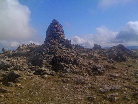
The summit of Raise, 883m
From here, it was mostly a series of gentle (but still rock strewn) descents along the tops until the descent to Grisedale Tarn. It was also where I picked up the tourist trail, and the peace and quiet I had thus far been revelling in was shattered by numerous walkers. 
The descent from Raise towards Helvellyn
But nothing could detract from the views, and as I descended White Side, the steep ridge of Lower Man loomed ahead of me, ready to be climbed in order to reach Helvellyn. This was actually great fun. The exposed ridge was extremely windy, but it added to my exhilaration as I gradually got higher and higher up the range. 
Looking up at the climb of Lower Man to Helvellyn
Eventually I reached the top, and it was an easy walk from there along to the peak of Helvellyn, where apart from taking the obligatory photos, I didn’t hang around as it was reminiscent of Oxford Street on a Saturday afternoon. 
From the top of Helvellyn, 950m

From the top of Helvellyn, 950m

From the top of Helvellyn, 950m
Easy, albeit breezy, walking along the tops along Nethermost Pike and Dollywaggon Pike and it was the a long descent down to about 500m to Grisedale Tarn. 
Looking down at Grisedale Tarn from Dollywaggon Pike, 858m

Looking south from Dollywaggon Pike

Grisdale Tarn and Dollywaggon Pike
The path here was in a v shape, and not being able to see the tip of the v, I cut across. In front of me was a bank about 2ft high, so in order to get the height required to step up, I threw down my right foot onto the ground. Only to realise it wasn’t ground, it was a bog, and I was now stuck in it up to my knee. As I lost my balance, the other leg fell in too. Meh. At first I couldn’t move, but somehow managed to free my left leg, then using as much force as I could muster, pulled my right leg out too. For a change I had done my laces up quite tightly, and my feet were freed with both shoes thankfully still attached. However I had half of the bog still attached to me, so I decided to sit myself on the bank of the tarn, took my socks and shoes off, and went for a lovely paddle to clean up. Given the warmth of the day, and my increasing thirst, it was heavenly. In fact, if I’d known what was coming up, I may just have stayed there. 
The ascent to Fairfield
Having wasted enough time paddling (it was supposed to be a race!) I moved on and found the crosstracks which marked the ascent to Fairfield. Except the path disappeared halfway up, so clearly this was the wrong way and there must be another path somewhere. 
The ascent to Fairfield
Except there wasn’t. The extremely close-together contour lines on the map confirmed that this was indeed the required ascent, and in lieu of a walkable path, I’d just have to do some rock climbing. Eek. It was about halfway up that I realised just why I was scared of heights. It’s not an irrational fear – I was clinging to the side of a mountain, hanging on to rocks, and trying to deal with the fact that almost every time I grabbed a rock to cling onto it moved away from the side. Being scared was an entirely natural response, I think. And I was so scared. I think it was the most terrifying thing I have ever done. I certainly can’t remember being that scared before. But if I thought it was bad going up, I could not bear the thought of going down – each time I looked down it seemed to be a vertical drop to the water at the bottom, 300 odd metres below me. I know people do descend down there, I just don’t know how they do it. I reached the top, and almost burst into tears at the sheer relief of not being dead. I felt a surge of confidence. If I could do that, surely I could do anything? 
Looking down from the ascent to Fairfield, 873m. The most terrifying thing I have ever done.
From the top of Fairfield was the gradual descent (with a few more ascents thrown in) down to home for the evening at Rydal Hall. The lack of water was making running a struggle, even on the runnable bits, and I made very slow progress, but progress is progress. 
Heading south from Fairfield

Rydal Head & Rydal Fell

Heading south from Fairfield
I saw some of the crew about half a mile out from the finish, and gratefully accepted some water, before legging it down the hill. 
Windermere and Rydal Water from Heron Pike, 612m
|
Saturday, 27 December 2014
Day 3
Subscribe to:
Post Comments (Atom)
No comments:
Post a Comment